
Geographic Information System
What is GIS?
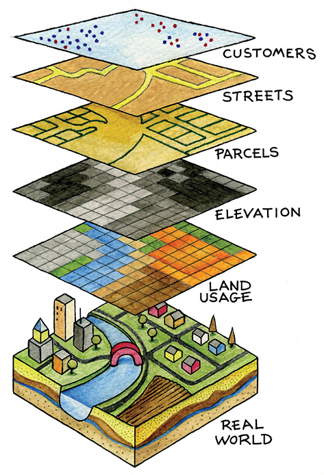
The Power of Mapping
The Bluegrass Area Development District’s GIS Department offers a technical background and a data repository for local communities and utilities to utilize for the purposes of decision-making, emergency management, and planning.
Capabilities of the GIS Staff are emphasized by their combined knowledge and experience, specialized tools and equipment, and the manpower it takes to provide different services throughout the Bluegrass Region. These services range from E911 data collection, to planning and zoning, to technical assistance. Currently, the GIS Department provides services to several counties and cities within the Bluegrass ADD that include but are not limited to: Jessamine County, Boyle County, Estill County, Bourbon County, Versailles, Lancaster, and Jessamine Water District #1.
The GIS Department has been using ESRI-based products for an extended period of time and therefore, has extensive knowledge of ESRI’s most current software: ArcMap ArcInfo, ArcSDE, ArcServer, and also uses ArcPad as a field-based data collection tool. In addition, the GIS Department currently uses Trimble Global Positioning Equipment (GPS) and possesses a sub meter accurate base station.
E911 data collection
This service can include structure collection, E911 indexed wall map, indexed map book, ADD-Vantage, Automatic Location Identifier (ALI) and Master Street Address Guide (MSAG) scrubbing, and provide data in formats required by individual 911 CAD systems.
E911 updates and maintenance
This service can include the update of structures as they are constructed, the elimination of zero address, the updating of any maps, map books, and CAD systems as needed.
Land use mapping
GIS will use all data available from parcels, structure points, aerial photography, and field visits to create the most accurate land use maps possible, based on scope of work and comprehensive plan requirements. These can also be made available for internet use as either secured or non-secured websites. In addition, GIS has the capability to also provide digital data as an end product for local maintenance and updating.
Zone mapping
Based on scope of work, GIS will COGO all ordinances provided, correct existing zones, and deliver in the format of a map.. The zoning maps can also be made available on the internet as either secured or non-secured websites. The GIS staff can also provide digital data as an end product for local maintenance and updating.
Web mapping (ArcServer)
All mapping can be made available on the internet as either secured or non-secured websites. Please visit our Online Maps
Utility mapping and collection
This service can include the collection of valve locations, manholes, water tanks, meters, hydrants, wastewater treatment plants, water treatment plants, a wall map of systems, and a map book of systems. This information can be provided in a format that is easily incorporated into commonly used modeling software. All mapping can be made available on the internet as either a secured or non-secured websites.
Utility updates and maintenance
This service can include the updating of valves, manholes, water tanks, meters, and hydrants as they are constructed and added to the system. Utility updates also include the revision of wall maps and map books as needed or based on the scope of work.
Annexation maintenance
The GIS staff will be happy to assist cities in determining where their current city boundaries are located in preparation for new annexations. Please note that Bluegrass ADD’s GIS Department Staff are not licensed surveyors.
GIS ADD-Vantage
The GIS ADD-Vantage software was developed by a consortium of Area Development Districts to provide local cities and counties access to mobile GIS data. This product was initially designed for use in Emergency Service Vehicles; however, we soon realized that the ADD-Vantage had much more potential.
The GIS ADD-Vantage is a custom program that utilizes ESRI’s ArcReader as a host. It enhances the standard functionality of ArcReader, allowing users to search for structure points to locate addresses or approximate an address using road centerlines. GIS ADD-Vantage also provides the user with the versatility to connect low-end GPS units and display their current positions.
The GIS ADD-Vantage is a well rounded program that gives Emergency Service Personnel the ability to quickly identify current locations, locate addresses, and print maps. For more information give us a call.
Awards:
The Bluegrass Area Development District’s (Bluegrass ADD) GIS Staff recently received an award from the Kentucky Chapter of the Kentucky Emergency Number Association for their dedication to improve 9-1-1 services in the state of Kentucky.
Contact
James Whisenhunt – GIS Manager
699 Perimeter Drive
Lexington, KY 40517
(859) 269-8021
(859) 269-7917 (FAX)
jamesw@bgadd.org
In the Spotlight
Awards & Recognition
Publications
Awards
Years Experience
Maps
Features
What We Offer
GPS
Phasellus ac massa justo. Pellentesque porttitor, ex nec dignissim congue, ex enim fermentum nunc, quis sagittis velit.
Analytics
Phasellus ac massa justo. Pellentesque porttitor, ex nec dignissim congue, ex enim fermentum nunc, quis sagittis velit.
Maps
Phasellus ac massa justo. Pellentesque porttitor, ex nec dignissim congue, ex enim fermentum nunc, quis sagittis velit.